FloodMind - DestinE ML Demonstrator on Flood Nowcasting
Overview
FloodMind is a machine learning demonstrator, developed by HydroLogic within the Destination Earth (DestinE) impact sector framework, that provides short-range probabilistic pluvial flood predictions. It combines two complementary machine learning components: a precipitation nowcast blending model and a flood inundation model, delivering hourly water depth forecasts up to 24 hours ahead for use by water managers, municipalities and safety regions.
The service is designed to support operational decision-making during extreme rainfall events, in particular within the 2-8 hour “decision window” in which preventive action can still reduce flood impact. The operational service runs on HydroLogic’s infrastructure.
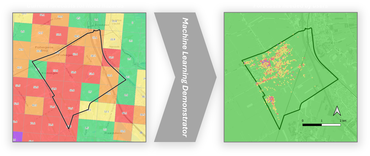
Illustration of the knowledge gap that will be filled by DestinE FloodMIND. Colours represent the risk of flooding, from green (no risk) to red (high risk).
Service Description
FloodMind consists of two ML models that work together, plus a visualization layer:
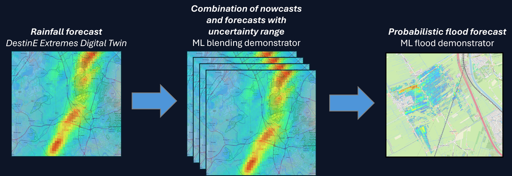
From rainfall forecast to flood risk: a DestinE Extremes Digital Twin rainfall forecast is combined with nowcasts by the ML blending demonstrator into an ensemble capturing the uncertainty range, which the ML flood demonstrator then turns into a probabilistic flood forecast.
Precipitation nowcast blending
Short-term radar-based nowcasts (produced with the Deep Generative Model of Radar, DGMR) are blended with numerical weather prediction forecasts from ECMWF’s Weather-Induced Extremes Digital Twin (ExtremesDT) and the IFS Ensemble, using a scale-dependent cascade blending approach extended from the open-source pySTEPS library. Blending weights are optimized per forecast case using Bayesian optimization, and a trained classifier predicts near-optimal weights in real time so the blend can run operationally without case-by-case tuning. The blended precipitation ensemble is the rainfall input to the flood model.
Flood inundation forecasting
A U-Net convolutional neural network predicts hourly pluvial water depth from rainfall and terrain data (elevation, slope and aspect). The model is autoregressive: each hourly water depth prediction is fed back in as input for the next hour, producing a rolling 24-hour flood forecast. It was trained on hydraulic simulations (D-HYDRO / Delft3D FM) covering more than 769 terrain domains and 9,300 rainfall events sampled across Europe, using historical radar rainfall augmented in time and space to increase scenario diversity.
For four Dutch pilot areas, an optional rainfall preprocessing step accounts for local infiltration, pumping stations, sewer drainage capacity and river discharge, improving accuracy in areas where these processes materially affect flooding.
Validation and performance
Flood extent accuracy is tracked using the Critical Success Index (CSI) at two depth thresholds (0.05 m and 0.30 m), with a target of 0.70. Across all evaluation sets - including previously unseen rainfall events and previously unseen geographic domains - CSI scores are in the range of approximately 0.72-0.76, meeting the target and indicating that the model generalizes well beyond its training data. The optimized precipitation blend also outperforms both the raw nowcast and a non-optimized blend, with the largest gains (up to ~13%) within the 2-8 hour decision window.
Visualization
Forecasts are visualized in GeoWeb, an open-source meteorological workstation (KNMI, FMI, MetNo), served through an ADAGUC-server backend. Each pilot area has a preconfigured workspace with:
Rainfall and cumulative rainfall maps, and a water depth map, with a choice of continuous or threshold-based (e.g. >25 cm highlighted) display styles.
A time slider covering nowcast time to +24 hours, and an ensemble member slider to explore forecast uncertainty.
Location-specific time series (rainfall, cumulative rainfall, water depth) shown when a user clicks on the map.
A “what-if” preset per pilot area that replays a significant historical rainfall event, so users can explore system behaviour under high-impact conditions without waiting for a real event.
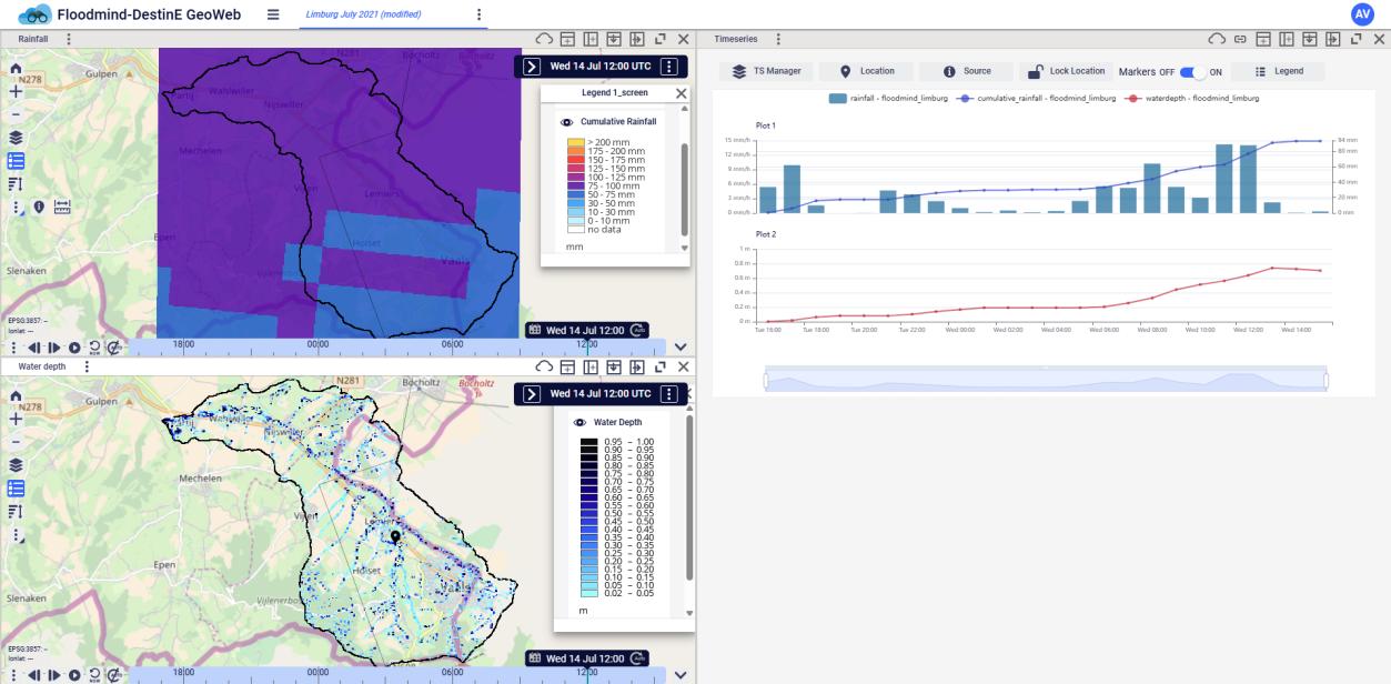
The FloodMind GeoWeb workspace, showing cumulative rainfall (top) and predicted water depth (bottom) for a historical event in Limburg, with the corresponding rainfall and water depth time series on the right.
Pilot areas
Pilot area |
Historical event simulated |
|---|---|
HDSR - Polder de Tol |
July 2014 |
Vallei en Veluwe - Barneveldse Beek |
August 2020 |
Limburg - Selzerbeek |
July 2021 |
Tilburg |
July 2014 |
New Zealand |
March 2026 |
South Africa |
January 2026 |
Note
For the New Zealand and South Africa pilot areas, only the historical what-if scenario is currently available; the operational blending model does not yet generate live forecasts for these locations.
Access
FloodMind has no API in this deployment. The service is accessed through its web-based GeoWeb interface, publicly available at:
https://floodmind-geoweb-services.hydrologic.com/The operational service runs on HydroLogic’s infrastructure.
Usage
Open the service URL and select the workspace for your pilot area of interest. Dutch pilot areas offer both a live operational forecast workspace and a historic what-if workspace; New Zealand and South Africa currently offer the historic what-if workspace only.
Use the two map panels to view current and forecast rainfall (cumulative and instantaneous) and predicted water depth.
Use the time slider to move from nowcast time out to +24 hours, and the ensemble member slider to compare individual ensemble members.
Click any point on the map to open a location-specific time series of rainfall, cumulative rainfall and water depth.
Switch to a what-if preset to replay a historical high-impact event for the same area.
Support
For questions about FloodMind, or to report an issue, contact the HydroLogic service desk: servicedesk@hydrologic.com