Impact Sector Applications
The Climate DT includes six impact-sector applications that process climate model output to derive sector-specific indicators. These applications are aligned with the Destination Earth use cases and operate as integrated components of the Climate DT workflow.
The applications deliver information at the spatial and temporal resolution of the Climate DT simulations and have been developed in collaboration with users from relevant sectors.
|
Derives wind and solar energy metrics from Climate DT simulations. Outputs include wind speed at hub height, wind and photovoltaic capacity factors, heating and cooling degree days, and wind-related extreme-event metrics. Indicators are produced at kilometre-scale resolution and are available globally. |
|

|
Provides wind statistics and related indicators tailored to offshore wind energy applications. |

|
Wildfires FWI and Wildfires WISE Combines the Canadian Forest Fire Weather Index (FWI) with the Wildfire Intelligence and Simulation Engine (WISE). FWI provides daily fire-weather danger metrics at continental to global scales, while WISE simulates localised fire spread at high spatial and temporal resolution. |

|
Provides information on freshwater availability using the mesoscale Hydrologic Model (mHM) driven by Climate DT output. Key variables include river discharge and soil moisture, from which drought and flood-related indices are derived. |

|
Derives extreme precipitation statistics from Climate DT simulations, including event catalogues and intensity estimates for specified return periods and durations. The application supports infrastructure planning and climate risk assessment. |
Integration within the Climate DT Workflow
Impact-sector applications are integrated within the Climate DT production workflow and process data as it is generated by the coupled models (see apps_in_workflow). The output from all three models can be processed the same way by the apps due to the Generic State Vector (GSV) that unifies the model output to a large extent. Before the data is processed by the applications the data goes through the One-pass Algorithm and potentially through Bias adjustment.
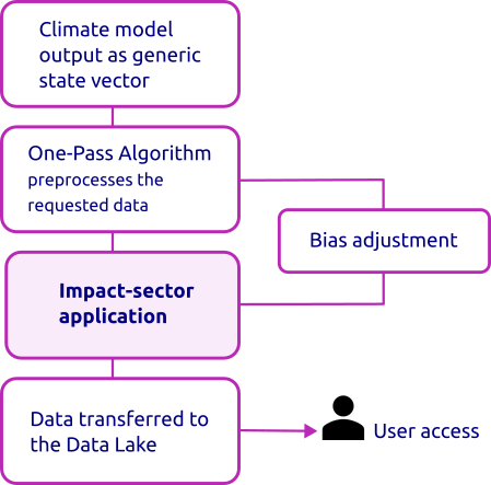
Schematic of impact-sector applications within the Climate DT workflow.
One-Pass Algorithm (OPA)
The OPA incrementally computes statistical metrics as data becomes available, without requiring access to the full temporal record. Available statistics include percentiles, histograms and annual maxima.
Bias Adjustment (BA)
Bias adjustment can be applied to selected variables using quantile mapping against reference datasets. This component operates within the streaming workflow and is primarily applied to precipitation and temperature. Currently, only HydroLand uses Bias Adjustment.
Accessing the data
Note
Information on accessing the data for this application will be published in an upcoming update. For access to Climate DT simulation data, see Data and Access.